
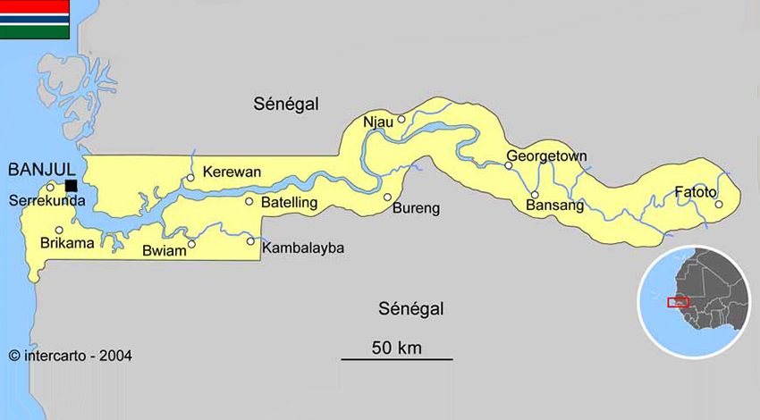
1.1 Geographic and politics characteristics of Gambia
Political system
The Gambia gained its independence from the UK in 1965. Geographically surrounded by Senegal, it formed a short-lived Confederation of Senegambia between 1982 and 1989. In 1991 the two nations signed a friendship and cooperation treaty, although tensions flared up intermittently during the regime of Yahya JAMMEH.
JAMMEH led a military coup in 1994 that overthrew the president and banned political activity. The President directly elected by simple majority popular vote for a 5-year term (no term limits); election last held on 1 December 2016 (next to be held in 2021); vice president appointed by the president.
JAMMEH led a military coup in 1994 that overthrew the president and banned political activity. The President directly elected by simple majority popular vote for a 5-year term (no term limits); election last held on 1 December 2016 (next to be held in 2021); vice president appointed by the president.
- Area : 11.300 km2
- Population : 2.092.731 (July 2018)
- Density : 185 people/km2
- Population growth rate : 1.99%
- Urban population : 61.3% (2018)
- Official language : English
International agreements
Member of West African Monetary Zone, The Gambia is also part of Economic Community of West African State with Benin, Burkina-Faso, Cap Verde, Cote d’Ivoire, The Gambia, Guinea, Bissau Guinea, Liberia, Mali, Niger, Nigeria, Senegal, Sierra Leone and Togo.
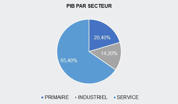
1.2 Macroecononic Framework
1.3 Economic performance and outlook of Gambia
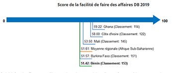
1.4 Ease of Doing Business
- Benin (capital : Porto-Novo)
- Burkina Faso (capital : Ouagadougou)
- Cape Verde (capital : Praia)
- Ivory Cost (capital : Abidjan)
- Gambia (capital : Banjul)
- Ghana (capital : Accra)
- Guinea (capital : Conakry)
- Guinea Bissau (capital : Bissau)
- Liberia (capital : Monrovia)
- Mali (capital : Bamako)
- Niger (capital : Niamey)
- Nigeria (capital : Abuja)
- Senegal (capital : Dakar)
- Sierra Leone (capital : Freetown)
- Togo (capital : Lomé)


