
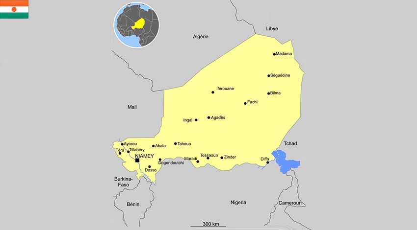
1.1 Geographic and politics characteristics of Niger
Political system
Niger became independent from France in 1960 and experienced single-party and military rule until 1991, when Gen. Ali SAIBOU was forced by public pressure to allow multiparty elections, which resulted in a democratic government in 1993.
The president directly elected by absolute majority popular vote in 2 rounds if needed for a 5-year term (eligible for a second term); election last held on 21 February 2016 with a runoff on 20 March 2016 (next to be held in 2021); prime minister appointed by the president, authorized by the National Assembly.
- Area : 1.269.000 km2
- Population : 19.866.231 (July 2018)
- Density : 15 people/km2
- Population growth rate : 3.16%
- Urban population : 16.4% (2018)
- Official language : French
International agreements
Member of West African Economic Monetary Union, Niger is also part of Economic Community of West African State with Benin, Burkina-Faso, Cape Verde, Cote d’Ivoire, The Gambia, Guinea, Bissau Guinea, Liberia, Mali, Niger, Nigeria, Senegal, Sierra Leone and Togo.
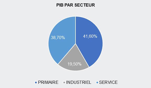
1.2 Macroecononic Framework
1.3 Economic performance and outlook of Niger
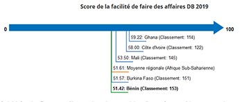
1.4 L’environnement des affaires / Ease of Doing Business
- Benin (capital : Porto-Novo)
- Burkina Faso (capital : Ouagadougou)
- Cape Verde (capital : Praia)
- Ivory Cost (capital : Abidjan)
- Gambia (capital : Banjul)
- Ghana (capital : Accra)
- Guinea (capital : Conakry)
- Guinea Bissau (capital : Bissau)
- Liberia (capital : Monrovia)
- Mali (capital : Bamako)
- Niger (capital : Niamey)
- Nigeria (capital : Abuja)
- Senegal (capital : Dakar)
- Sierra Leone (capital : Freetown)
- Togo (capital : Lomé)


